Industrial and field analysis equipment - Software and digital applications - Natural resources and territories
- Home
- Work with us
- Cirad'Innov solutions
- Products and services
- MASH
MASH : monitoring the sugarcane harvest
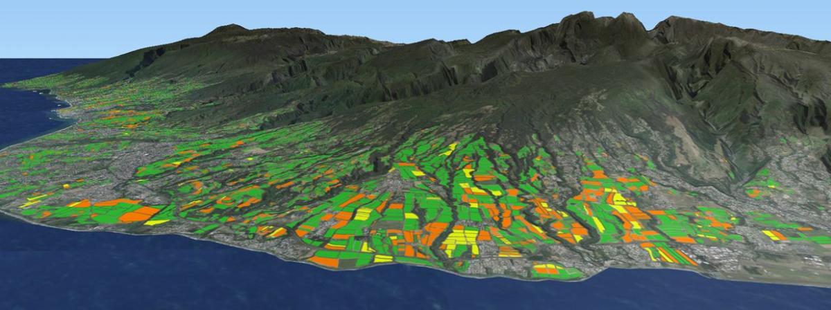
Sugarcane harvest mapping and monitoring using radar satellite imagery in La Réunion island © Mickael Mézino, CIRAD
A tool for optimizing sugarcane production
Mash (Mapping Sugarcane Harvest) is an application for mapping sugarcane harvest progress in semi-real time. The method consists in automatically processing free satellite images (radar and optical) acquired with high repeatability (less than 6 days). Each pixel of sugarcane plots is classified according to its harvest status. Mash produces synthetic maps of harvested area rates by plot, as well as synthetic tables by supply center, or by factory, enabling operators to visually monitor harvest progress.
The Mash chain is based exclusively on free satellite data from the European Space Agency's (ESA) Copernicus program and Open Source software. It is deployed on a Linux server.
Development stage
Benefits for sugarcane production
Mash is a decision-support module that :
- Gives an overview of the state of harvesting in a given geographical area;
- Optimizes the supply chain around the sugarcane harvest;
- Facilitates the management of manpower and field operations.
Mash, which focuses on harvesting processes, currently complements the yield estimation solution developed by our partner GeoWtach Labs to provide a better range of services.
Mash markets and applications
- For sugarcane operators: a tool for optimizing sugarcane harvest logistics and updating harvest area forecasts. Mash provides precise information on the area of cane actually harvested and its distribution across the country
- For the industry's institutions and economic partners on a regional scale: the harvested area rate on a regional scale is a particularly complicated piece of information to obtain, given that sugarcane production is often spread over thousands of small producers. Mash provides simple, map-based access to this information.
How to access the Mash tool and related services?
The research team that developed Mash offers :
Sugarcane millers and processors :
Integrate the Mash application into their own logistics management tools.
Imaging service operators:
Transfer the technology to them, with a view to licensing it in certain countries/regions and incorporating it into their solution, as GeoWatch Labs does.
For all other requests, particularly from political and statistical institutions, please do not hesitate to contact us.
For further information: https://smartis.re/p/MASH
References and intellectual property
Patents and licenses :
APP filing IDDN n° FR.001.18008.00 of April 23, 2019
The module has been transferred to GeoWatch Labs for integration into their production chain. This transfer is non-exclusive, however, and enables us to take into account additional specific requirements.
Publications
Baghdadi N., Boyer N., Todoroff P., El Hajj M., and Begue A., 2009. Potential of SAR sensors TerraSAR-X, ASAR/ENVISAT, and PALSAR/ALOS for monitoring sugarcane crops on Reunion Island. Remote Sensing of Environment, vol.113, Issue 8, pp. 1724-1738. http://publications.cirad.fr/une_notice.php?dk=549410
Baghdadi, N., Cresson, R., Todoroff, P., Moinet, S., 2010. Multitemporal Observations of Sugarcane by TerraSAR-X Images. Sensors 10, 8899-8919. http://dx.doi.org/10.3390/s101008899

